View Tract Details

FALLING CREEK FALLS

Recreation
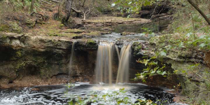
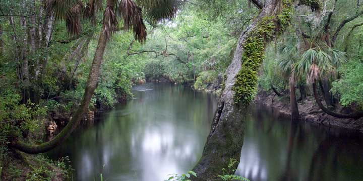
Falling Creek Falls is one of the District’s gems. During normal water levels the creek roars over a 10-foot waterfall and flows under Falling Creek Road through a deep ravine before going underground.

The park area is managed through a partnership with Columbia County. For park information, contact Columbia County. The District portion of the tract can be access through the county park.

386-758-2123
Columbia County Florida Website

Access
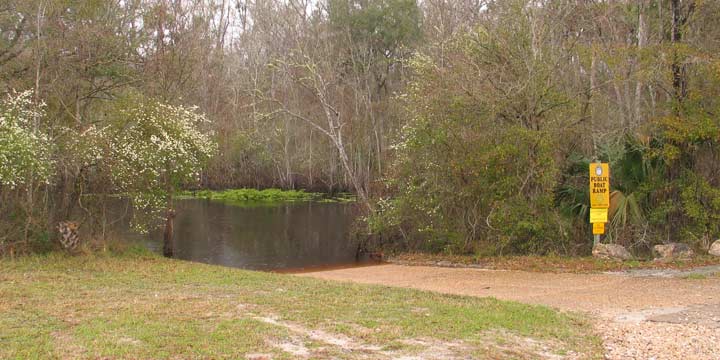
Falling Creek Falls Tract from Lake City:
Travel north on US 41, pass under I-10, turn right on NW Falling Creek Road; travel 1 mile. The park is on the right before crossing the creek.

View Tract Details

GAR POND

Recreation
On the Gar Pond Tract, visitors may enjoy biking, hiking, and horseback riding on designated trails and wildlife viewing . Fishing is allowed in Pit Pond.

Gar Pond Trail is a 11-mile trail marked with three-inch yellow disk with a bicycle icon or blue blazes. The trail is open to bicycling and hiking. For bicyclists, the trail is a fast, single track suitable for all skill levels. There are several shortcuts back to the trailhead for the tired and weary.  Hikers can enjoy a scenic hike through the diverse vegetation with some elevation changes along the way.

Access
Gar Pond Tract from White Springs:

Travel south on US 41, cross the Suwannee River past the inspection station turn right at the entrance sign.

View Tract Details

GOOSE PASTURE

Recreation
Visitors may enjoy biking, hiking, horseback riding, and wildlife viewing on administrative roads, in addition to fishing and hunting.

The Goose Pasture tract is a part of the Aucilla Wildlife Management Area. For more information on hunting, contact the Florida Fish and Wildlife Conservation Commission at:

850-265-3676
Florida Fish and Wildlife Conservation Commission Website
Aucilla Bird List (PDF)

Note: Hunting is only allowed in permitted areas.


Camping Area
The primitive camping area is open on a first-come, first-served basis by self-issued special use authorization, which is available at the kiosk. Campers are limited to a 10-day stay. Camping is not allowed during general gun season. The group camping area can be reserved for groups of six or more by contacting the District at:

386-362-1001
800-226-1066 (FL only)
Email Recreation


Access
Goose Pasture tract from Perry:
Travel 22 miles west on US 98 to Powell Hammock Road, turn right; travel north 4 miles, turn left on Goose Pasture Road; travel west 2.75 miles and the tract is on both sides of the road. Continue traveling west 1 mile and the road ends at Goose Pasture Campground.

View Tract Details

CHRISTIAN

Recreation
The Christian Tract north river access point provides a canoe launch, and the south parking area overlooks Shirley Springs. Visitors may enjoy fishing, as well as biking, hiking, horseback riding, and wildlife viewing on administrative roads.

Access
Christian Tract from Live Oak:
Travel SR 51 south, turn right on CR 250; travel 10 miles to 225th Road, turn left; travel 3 miles, turn right on 132nd Street; travel 1 mile to 233rd Road, cross the road to the entrance of the Christian Tract.

View Tract Details

CABBAGE CREEK

Recreation
Visitors may enjoy biking, hiking, horseback riding, and wildlife viewing. in addition to fishing and hunting. Many of the river access points provide launches for canoes or small boats. Cabbage Creek Tract is part of the Lower Econfina River Wildlife Management Area.

The Econfina River traverses the tract from the north boundary to the southern boundary.  The river’s 239-square mile basin drains part of the Big Bend Region.  Its headwaters in San Pedro Bay the Econfina River’s character changes dramatically as it winds 44-miles through upland forests and meanders downstream to the palm-fringed salt marshes of the Gulf of Mexico.

The name “Econfina” derives from the Creek ekana, which means “earthy”, and feno, which means “bridge” or “foot log”. This name may refer to a natural bridge over the river in the Natural Well Branch Tract.

Hunting is allowed in permitted areas only. For more information on hunting, contact the Florida Fish and Wildlife Conservation Commission at:

386-758-0525
Florida Fish and Wildlife Conservation Commission Website

Access
Cabbage Creek Tract from Perry:
Travel west 16 miles on US 98, turn right into the boat ramp parking lot.

West Entrance from Perry:
Travel across the river on US 98, turn right on the Loughridge Grade (the first road to the right) and the tract is on the right.

North Entrance from Perry:
Travel west on US 98, veer right on Salt Grade; travel 3.5 miles and the entrance is on the left.

View Tract Details

CABBAGE GROVE

Recreation
On the Cabbage Grove visitors may enjoy biking, hiking, horseback riding, and wildlife viewing, in addition to fishing and hunting. Many of the river access points provide launches for canoe or small boats.

Cabbage Grove is part of the Aucilla Wildlife Management Area. Hunting is allowed in permitted areas only. For more information contact the Florida Fish and Wildlife Conservation Commission at:

850-265-3676
Florida Fish and Wildlife Conservation Commission Website
Aucilla Bird List


Access
Cabbage Grove Tract from Perry:
Travel 22 miles west on US 98 to Powell Hammock Road, turn right; travel north 4 miles, turn left on Goose Pasture Road; travel west .25 miles and the tract is on the right.


View Tract Details

CAMP BRANCH

Recreation
Visitors may enjoy fishing, hiking, and wildlife viewing on administrative roads and designated trails. The Florida National Scenic Trail traverses the Camp Branch tract along the river.

Access
Camp Branch tract from White Springs:
Travel west on CR 25A, turn left past the Camp Branch road sign onto an unnamed road; follow road approximately 1 mile to the parking area.

Size
Camp Branch – 200 acres

View Tract Details

CHITTY BEND EAST TRSF

Recreation
Visitors may enjoy fishing, as well as biking, horseback riding, hiking, and wildlife viewing on administrative roads.

This tract is part of Twin Rivers State Forest. For more information, call or visit:

386-208-1460
Florida Department of Agriculture and Consumer Services Website

Access

Chitty Bend East tract from Lee:
Travel north on CR 255, turn right on SR 6; travel east 5 miles, turn left on NW CR 143; travel north 1.25 miles, turn left on NW 40th Loop; follow the road and it becomes NW 23rd Boulevard; turn left on NW 34th Street; travel 2 miles and the tract entrance is on the left.

View Tract Details

CHITTY BEND WEST

Recreation
Visitors may enjoy fishing, as well as biking, hiking, horseback riding, and wildlife viewing on administrative roads.

This tract is part of Twin Rivers State Forest. For more information, call or visit:

386-208-1460
Florida Department of Agriculture and Consumer Services Website

Access
Chitty Bend West Tract from Lee:
Travel north on CR 255, turn right on SR 6; travel east 2 miles, turn left on Old Blue Springs Road; travel 3.25 miles north, turn right on NE Cottonwood Street and the tract is at the end of the road.


View Tract Details

CHITTY BEND WEST TRSF

Recreation
Visitors may enjoy fishing, as well as biking, hiking, horseback riding, and wildlife viewing on administrative roads.

This tract is part of Twin Rivers State Forest. For more information, call or visit:

386-208-1460
Florida Department of Agriculture and Consumer Services Website

Access
Chitty Bend West tract from Lee:
Travel north on CR 255, turn right on SR 6; travel east 2 miles, turn left on Old Blue Springs Road; travel 3.25 miles north, turn right on NE Cottonwood Street and the tract is at the end of the road.

Access
Chitty Bend West tract from Lee:
Travel north on CR 255, turn right on SR 6; travel east 2 miles, turn left on Old Blue Springs Road; travel 3.25 miles north, turn right on NE Cottonwood Street and the tract is at the end of the road.